The Global Navigation Satellite System (GNSS) is a system that allows to determine the spatial position of terrain objects by processing the received satellite signal by the GNSS receiver. GNSS consists of three segments: space, terrestrial and users. The space segment is a constellation of satellites orbiting the Earth's orbits. The terrestrial segment includes a network of tracking stations that monitor orbiting satellites and adjust their position. The user segment includes all the receivers that determine their location using GNSS.
Currently there are several GNSS:
|
GPS American satellite system
https://www.gps.gov
|
ГЛОНАСС Russian satellite
https://www.glonass-iac.ru/en/
|
Galileo European satellite system
https://galileognss.eu
|
Beidou Chinese satellite system
http://en.beidou.gov.cn
|


All satellite navigation systems are distinguished by the signal, the number of satellites in orbit, the orbital parameters of the flight of satellites. Almost all satellites transmit both civilian (open) and military (closed) signals. To determine the spatial location of a user with an accuracy of 3-15 m, it is enough to have a satellite navigation receiver.
Principle of GNSS operation
GNSS works as follows - the GNSS receiver measures the propagation time of the signal from the satellite to the receiver. The receiver receives satellite location information from the received signal. To determine the distance from the satellite to the receiver, the propagation time of the signal from the satellite to the GNSS receiver is multiplied by the speed of light. This method of measuring the distance from the satellite to the GNSS receiver is called code. There is a more accurate method of measuring the distance, called the phase. This method measures the number of radio waves that are placed within the distance from the satellite to the GNSS receiver and measures the phase of the last wave, which does not completely fit into this distance. The distance is obtained by multiplying the known wavelength by the number of waves plus the remainder of the last wave measured by its phase.
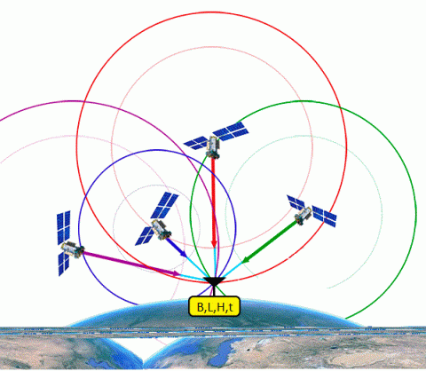
From the point of view of geometry, the GNSS operation can be illustrated as follows: several spheres in the middle of which are satellites. At the point of intersection of these spheres is the user. The radius of each sphere is accordingly equal to the distance to this visible satellite. Signals from three satellites give information about the latitude, longitude and height of the object, while the fourth satellite gives information about the exact time. Measured distances and coordinates of the satellites can be summarized in a system of equations from which the coordinates of the user can be calculated. Thus, to get the exact location you need to measure distances up to 4 satellites.
To determine the spatial position with higher accuracy, it is necessary to perform measurements in differential mode (ie, have two receivers, one of which acts as a base and must be set at a point with given coordinates, and the other acts as a rover "mobile" to determine the coordinates of the given points, both receivers must work simultaneously). There are two modes of measurement: post-processing and RTK (real-time). When using post-processing mode, field measurements are first performed at the set points, and then the data is transmitted from the receiver to the computer, and measurements are performed using specialized software. Real-time mode allows you to get the coordinates of the points directly in the field, this requires either radio communication or GSM communication between the base and rover receiver, provided with radio or GSM modems.