The problem of creating large-scale cadastral and general topographic plans is very acute in the regions of Ukraine. Because the materials available do not meet the requirements of the accuracy of the planned and altitude coordinates, as well as the reality of the situation.
Aerial photography is actively used in small and medium-sized objects (quarries, transport infrastructure, hard-to-reach areas), where rapid high-speed rapid shooting is required to obtain orthophoto and create digital terrain models (DTMs). Today, as a result of the implementation of the World Bank project (Project «Issuance of State Acts on Land Ownership in Rural Areas and Development of the Cadastre System» No. 4709 UA of October 17, 2003), more than 70% of the territory of Ukraine was aerial photography, orthophoto maps were created on the territory of more than 50% and index cadastral maps — to the territory of 10%. These figures indicate that there is an insufficient amount of mapping materials (especially large-scale maps) to create and fill up the national cadastral system and registration system in Ukraine with high-quality and updated information. Therefore, there is an urgent need to use UAVs for large-scale aerial surveying and mapping of territories.
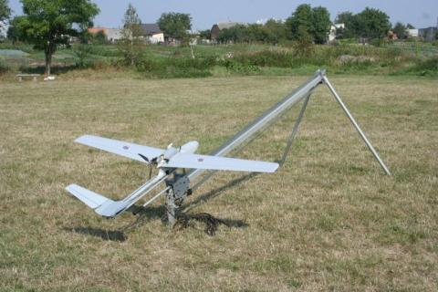
«Arrow» UAV before launch
For many years, scientists at the Institute of Geodesy have been engaged in the implementation of digital aerial survey techniques to create cadastral and topographic plans. The proposed technology of using UAVs in comparison with the existing one will make it possible to significantly reduce the process of creating cadastral plans. The introduction of the latest technologies for the creation of cadastral maps and plans will provide an opportunity to quickly and objectively fill the database of land information systems, which will allow (within a given scale) to output geospatial information from the level of individual objects and land to the level of basic administrative and territorial entities , administrative areas, and areas as needed. It will be able to organize the work of the State Service of Geodesy, Cartography and Cadastre of Ukraine at a fundamentally new qualitative level and will promptly provide local governments with cadastral information, which will improve management decisions in the area of territorial management and development, attract investment, serve as a geoinformation base for geoinformation Of Ukraine.
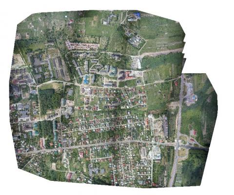
Vinnytsia Orthophoto Plan created in P.P. Pix4D